
Hilltop Cottage At Shady Grove
Lakes
There is a boat launch at Devil's Landing. Be sure to arrive very early in the summer months as only a certain number of boats are allowed to launch each day.
61 yerel halk öneriyor
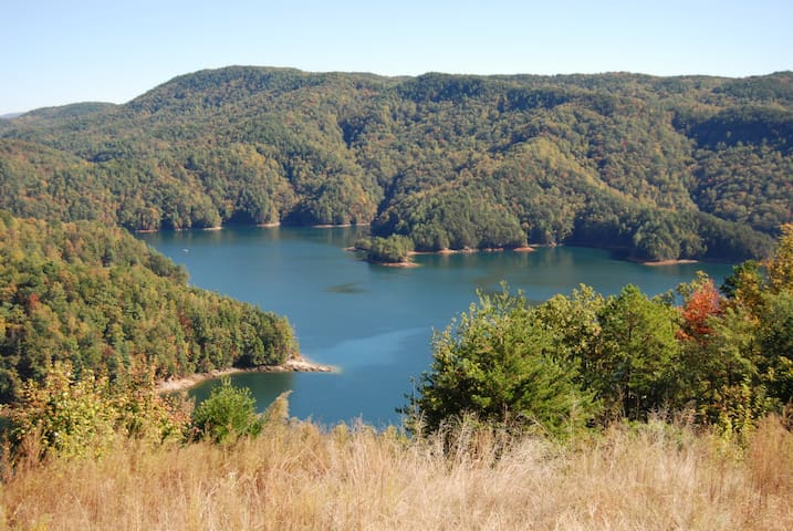
Lake Jocassee
There is a boat launch at Devil's Landing. Be sure to arrive very early in the summer months as only a certain number of boats are allowed to launch each day.
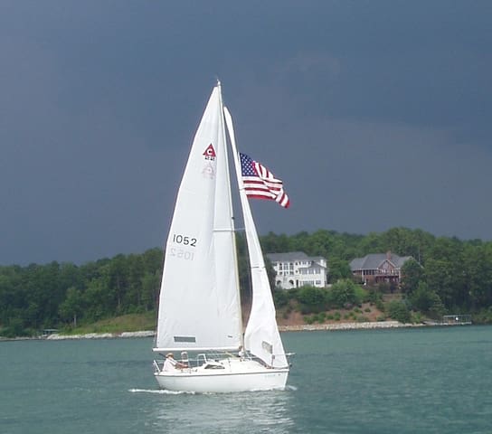
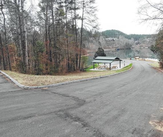
With 18,500 acres of water and a 300-mile shoreline, the Lake Keowee area is popular for fishing, waterskiing, swimming, camping and picnicking.
77 yerel halk öneriyor
Lake Keowee
With 18,500 acres of water and a 300-mile shoreline, the Lake Keowee area is popular for fishing, waterskiing, swimming, camping and picnicking.
Keowee Marina Drive
Keowee Marina DriveRent a boat from the Keowee Marina and explore our beautiful lake.
Hiking
Drive 1 hour
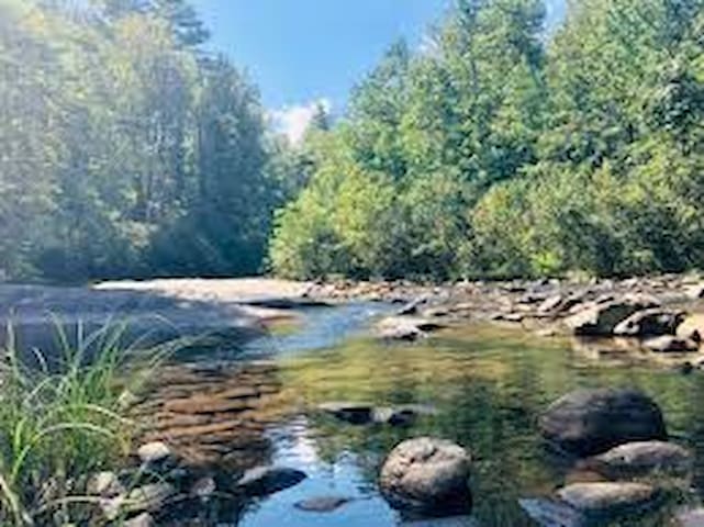
The river is one of the few remaining free-flowing streams in the Southeast. The Chattooga offers outstanding scenery, ranging from thundering falls and twisting rock-choked channels to narrow, cliff-enclosed deep pools. The setting is primitive; dense forests and undeveloped shorelines characterize the primitive nature of the area. No motorized vehicles are permitted within a corridor about 1/4-mile wide on either side of the river. Visitors must rely on their own skills and strength rather than on motorized equipment. Man-made facilities are minimal, consisting primarily of hiking trails.
42 yerel halk öneriyor
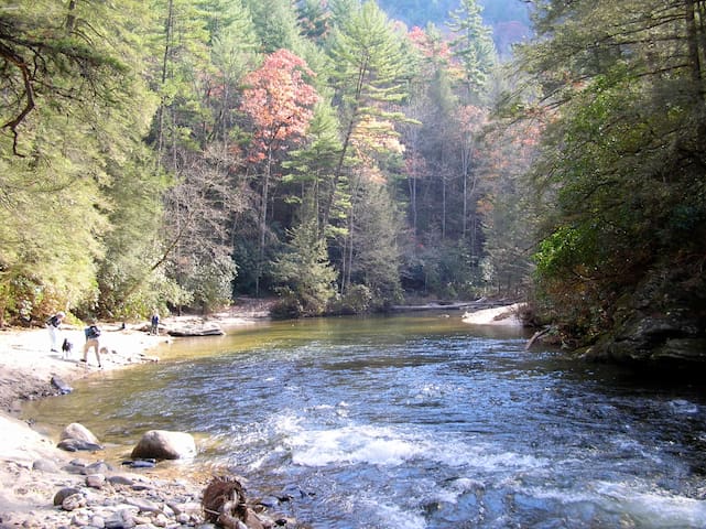
Chattooga River
Drive 1 hour
The river is one of the few remaining free-flowing streams in the Southeast. The Chattooga offers outstanding scenery, ranging from thundering falls and twisting rock-choked channels to narrow, cliff-enclosed deep pools. The setting is primitive; dense forests and undeveloped shorelines characterize the primitive nature of the area. No motorized vehicles are permitted within a corridor about 1/4-mile wide on either side of the river. Visitors must rely on their own skills and strength rather than on motorized equipment. Man-made facilities are minimal, consisting primarily of hiking trails.
18 Minute Drive
TWIN FALLS
SC PICTURE PROJECT
/ / TWIN FALLS
Twin Falls in the community of is by many accounts the most stunning waterfall in South Carolina. It is also the most easily accessible. Tucked in the Eastatoe (pronounced “EAST-a-tow-ee”) Valley, Twin Falls is part of a private, 25-acre nature preserve purchased in 1984 by the Florida-based Felburn Foundation. Admission is free and visitors are welcome!
37 yerel halk öneriyor
Twin Falls Trail
Waterfalls Road18 Minute Drive
TWIN FALLS
SC PICTURE PROJECT
/ / TWIN FALLS
Twin Falls in the community of is by many accounts the most stunning waterfall in South Carolina. It is also the most easily accessible. Tucked in the Eastatoe (pronounced “EAST-a-tow-ee”) Valley, Twin Falls is part of a private, 25-acre nature preserve purchased in 1984 by the Florida-based Felburn Foundation. Admission is free and visitors are welcome!
30 Minutes away
Sassafras Mountain is the highpoint of South Carolina. USGS maps put it at 3560 feet, but a recent South Carolina Geological Survey assessment downgraded to 3533 feet, mostly due to grading that lowered the natural height. That still puts it at least 50' higher than nearby Hickerynut Mountain (3,483'). Sassafras Mountain is located in Pickens County, in the Northwestern part of the state, off of a windy mountain road. Northwestern South Carolina is home to small mountain ranges, and Sassafras Mountain is lucky to get any recognition, since it is right on the border of North Carolina. From the top you can view 6,000' + mountains in the distance.
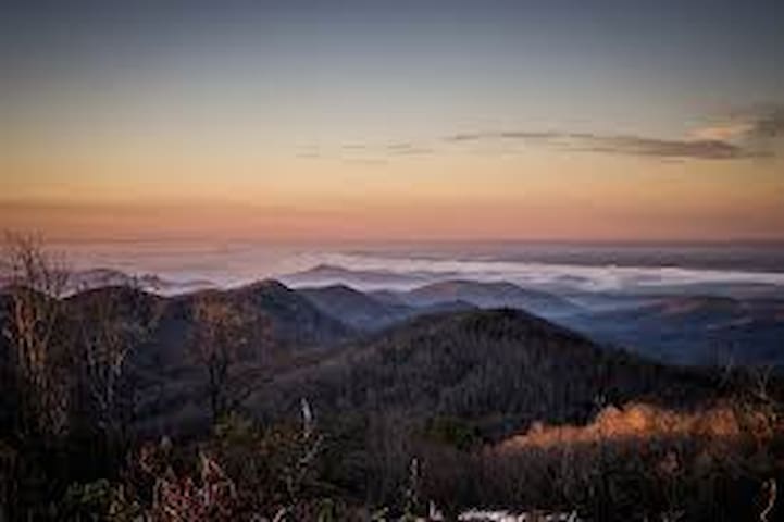
Sassafras Mountain Observation Tower
1391 F Van Clayton Memorial Hwy30 Minutes away
Sassafras Mountain is the highpoint of South Carolina. USGS maps put it at 3560 feet, but a recent South Carolina Geological Survey assessment downgraded to 3533 feet, mostly due to grading that lowered the natural height. That still puts it at least 50' higher than nearby Hickerynut Mountain (3,483'). Sassafras Mountain is located in Pickens County, in the Northwestern part of the state, off of a windy mountain road. Northwestern South Carolina is home to small mountain ranges, and Sassafras Mountain is lucky to get any recognition, since it is right on the border of North Carolina. From the top you can view 6,000' + mountains in the distance.
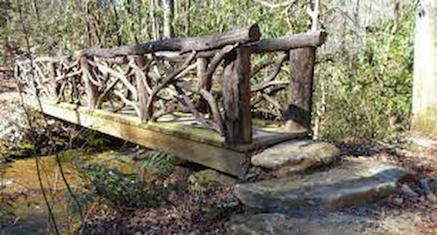
Perhaps no other trail in South Carolina provides such an extraordinary backcountry experience as the difficult, Foothills Trail in the northwest corner of the state. Starting with the 1.2 mile Foothills Access Trail in Oconee State Park, only the first 28 miles of the Foothills Trail from the park to Upper Whitewater Falls was designated a National Recreation Trail in 1979. By snaking along the Blue Ridge Escarpment, this trail and its many connectors provide almost 200 miles of hiking; most of it the rugged Appalachian greenbelt variety. The trail is accessible only to hikers, although vehicular access is available to many points along the main trail which, depending where you start, is either 80 or 85 miles long. Even so, considering numerous spur trails and connectors, an ambitious backpacker could hike the backcountry for more than a week.
9 yerel halk öneriyor
Foothills Trail
Winding Stairs RoadPerhaps no other trail in South Carolina provides such an extraordinary backcountry experience as the difficult, Foothills Trail in the northwest corner of the state. Starting with the 1.2 mile Foothills Access Trail in Oconee State Park, only the first 28 miles of the Foothills Trail from the park to Upper Whitewater Falls was designated a National Recreation Trail in 1979. By snaking along the Blue Ridge Escarpment, this trail and its many connectors provide almost 200 miles of hiking; most of it the rugged Appalachian greenbelt variety. The trail is accessible only to hikers, although vehicular access is available to many points along the main trail which, depending where you start, is either 80 or 85 miles long. Even so, considering numerous spur trails and connectors, an ambitious backpacker could hike the backcountry for more than a week.
Located in Oconee County of South Carolina just south of the North Carolina border is the amazing and impressive Lower Whitewater Falls. The falls are part of chain of waterfalls along the North and South Carolina border that is the highest series of falls in Eastern North America. This beautiful 200ft waterfall is viewable from an overlook that is a moderate 4 mile round trip hike
9 yerel halk öneriyor
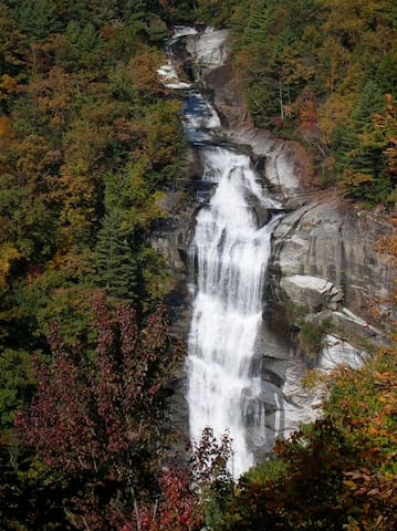
Lower Whitewater Falls Trail Access
Bad Creek RoadLocated in Oconee County of South Carolina just south of the North Carolina border is the amazing and impressive Lower Whitewater Falls. The falls are part of chain of waterfalls along the North and South Carolina border that is the highest series of falls in Eastern North America. This beautiful 200ft waterfall is viewable from an overlook that is a moderate 4 mile round trip hike
Sitting just outside the boundary of the Mountain Bridge Wilderness Area of South Carolina is one of the most beautiful waterfalls of South Carolina – Moonshine Falls. This 40ft waterfall is absolutely stunning as it falls in two sections. The upper section is a cave where the water separates from the rocks and free falls to the lower section where it forms a beautiful cascade flowing into a shallow crystal clear pool. The cave is also an interesting spot and is where the falls get there name. They used to make moonshine in the cave and some of the old barrels and equipment still remain to this day. This moderate hike to the fall is about 3 miles one way with about 700 feet of elevation gain. It is a great hike and includes an exciting river crossing via a cable hand bridge. You can also visit the short Asbury Cascade Falls which is just 500ft off the main trail. This little beauty is at a nice spot for a break and has a great swimming hole at the base of the falls. For the adventurous, there is also the beautiful Confusion Falls that is just 2/10’s of a mile past Moonshine Falls. Confusion Falls can be a bit of a challenge to reach and makes the hike strenuous. If you are interested in also seeing Confusion Falls, we created a separate episode for that.
Moonshine Falls
150 Asbury DriveSitting just outside the boundary of the Mountain Bridge Wilderness Area of South Carolina is one of the most beautiful waterfalls of South Carolina – Moonshine Falls. This 40ft waterfall is absolutely stunning as it falls in two sections. The upper section is a cave where the water separates from the rocks and free falls to the lower section where it forms a beautiful cascade flowing into a shallow crystal clear pool. The cave is also an interesting spot and is where the falls get there name. They used to make moonshine in the cave and some of the old barrels and equipment still remain to this day. This moderate hike to the fall is about 3 miles one way with about 700 feet of elevation gain. It is a great hike and includes an exciting river crossing via a cable hand bridge. You can also visit the short Asbury Cascade Falls which is just 500ft off the main trail. This little beauty is at a nice spot for a break and has a great swimming hole at the base of the falls. For the adventurous, there is also the beautiful Confusion Falls that is just 2/10’s of a mile past Moonshine Falls. Confusion Falls can be a bit of a challenge to reach and makes the hike strenuous. If you are interested in also seeing Confusion Falls, we created a separate episode for that.
The Eastatoe Creek Heritage Preserve is a 374 acre preserve in Pickens County in upstate South Carolina. Eastatoe Creek descends through a gorge in the preserve and is squeezed through the rock in an area called The Narrows. The hike is a 5 mile round trip on a well maintained trail and is moderate to difficult with the hardest part being the descent then ascent in and out of the gorge. I've been to this area several times now because it's such a unique area. You could also combine this hike with the hike to Virginia Hawkins Falls which is about 3 more miles up Horsepasture Rd.
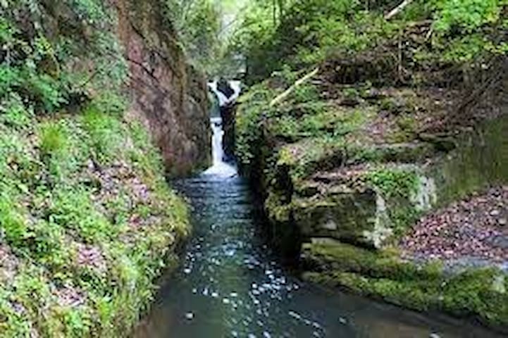
The Narrows Falls
The Eastatoe Creek Heritage Preserve is a 374 acre preserve in Pickens County in upstate South Carolina. Eastatoe Creek descends through a gorge in the preserve and is squeezed through the rock in an area called The Narrows. The hike is a 5 mile round trip on a well maintained trail and is moderate to difficult with the hardest part being the descent then ascent in and out of the gorge. I've been to this area several times now because it's such a unique area. You could also combine this hike with the hike to Virginia Hawkins Falls which is about 3 more miles up Horsepasture Rd.
Table Rock State Park hiking trails serve as an access point for the 76-mile Foothills Trail. South Carolina hikers can use to travel between several connected South Carolina State Parks. The Table Rock State Park hiking trails take hikers past mountain streams and waterfalls to the tops of Pinnacle and Table Rock mountains. While the park is well known to outdoor enthusiasts for its natural features, Table Rock also has its place in history. Many of the Table Rock State Park cabins and other structures built by the Civilian Conservation Corps remain standing and are on the National Register of Historic Places.
158 yerel halk öneriyor
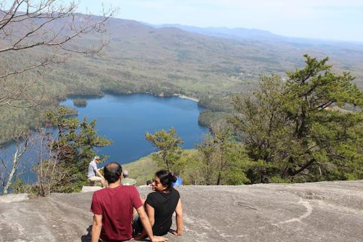
Table Rock Eyalet Parkı
158 E Ellison LnTable Rock State Park hiking trails serve as an access point for the 76-mile Foothills Trail. South Carolina hikers can use to travel between several connected South Carolina State Parks. The Table Rock State Park hiking trails take hikers past mountain streams and waterfalls to the tops of Pinnacle and Table Rock mountains. While the park is well known to outdoor enthusiasts for its natural features, Table Rock also has its place in history. Many of the Table Rock State Park cabins and other structures built by the Civilian Conservation Corps remain standing and are on the National Register of Historic Places.
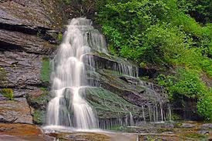
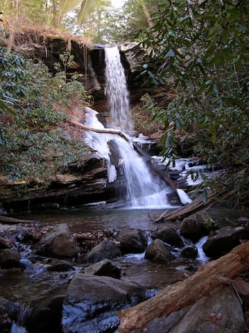
This SCDNR-created nature trail offers many scenic views and is a wonderful hike for outdoor recreation lovers. Beech Bottom Falls Trail was superbly built with excellent footbridges and steps along the route. There are water features throughout the trail, which leads to an observation deck for viewing Beech Bottom Falls (AKA Pinnacle Falls).
Beech Bottom Falls Trail
F Van Clayton Memorial HighwayThis SCDNR-created nature trail offers many scenic views and is a wonderful hike for outdoor recreation lovers. Beech Bottom Falls Trail was superbly built with excellent footbridges and steps along the route. There are water features throughout the trail, which leads to an observation deck for viewing Beech Bottom Falls (AKA Pinnacle Falls).
Keowee-Toxaway State Park is a state park in Pickens County, South Carolina. It was created in 1970 along the shores of Lake Keowee from lands previously owned by Duke Power. The Keowee-Toxaway Museum includes exhibits about the area Cherokee Indians and their interactions with local settlers
22 yerel halk öneriyor
Keowee Toxaway State Park
108 Residence DrKeowee-Toxaway State Park is a state park in Pickens County, South Carolina. It was created in 1970 along the shores of Lake Keowee from lands previously owned by Duke Power. The Keowee-Toxaway Museum includes exhibits about the area Cherokee Indians and their interactions with local settlers
With more than 50,000 acres of lush, protected forestlands and one of the highest concentrations of waterfalls in the eastern US, Jocassee Gorges offers a one-of-a-kind outdoor experience in South Carolina.
14 yerel halk öneriyor
Jocassee Gorges Wilderness Area
1344 Cleo Chapman HighwayWith more than 50,000 acres of lush, protected forestlands and one of the highest concentrations of waterfalls in the eastern US, Jocassee Gorges offers a one-of-a-kind outdoor experience in South Carolina.
The Andrew Pickens Ranger District is located in Oconee County on more than 85,000 acres. The district has a wide variety of programs and work across all functional areas including wildlife, fisheries, fire, timber, recreation, special uses and lands.
The management on the district emphasizes habitat restoration and enhancement for a diverse range of wildlife and plant species with emphasis on rare, threatened, endangered and sensitive species. Popular attractions on the district include hunting, fishing, hiking, fall color sightseeing, camping, horseback riding, and whitewater floating on the wild and scenic Chattooga River.
Sumter National Forest
The Andrew Pickens Ranger District is located in Oconee County on more than 85,000 acres. The district has a wide variety of programs and work across all functional areas including wildlife, fisheries, fire, timber, recreation, special uses and lands.
The management on the district emphasizes habitat restoration and enhancement for a diverse range of wildlife and plant species with emphasis on rare, threatened, endangered and sensitive species. Popular attractions on the district include hunting, fishing, hiking, fall color sightseeing, camping, horseback riding, and whitewater floating on the wild and scenic Chattooga River.
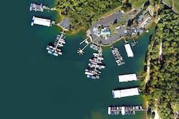
Boat Launch
Lake Keowee Real Estate Area Boating Hot Spots – Easy access just off of Hwy. 133. Near the Reserve. Good landing with plenty of parking off of the main body of the Lake
Crowe Creek Landing Boat Ramp
Crowe Creek Access RoadLake Keowee Real Estate Area Boating Hot Spots – Easy access just off of Hwy. 133. Near the Reserve. Good landing with plenty of parking off of the main body of the Lake
Launch your water adventure at Mile Creek Park. Easy access to the water is key here. Three paved boat ramps, two courtesy docks (108 feet long by eight feet wide), and convenient car and boat parking make it easy for you to bring your own boat or canoe. Another large, 150-foot dock has five slips. The docks are for immediate loading and unloading only; no long-term ties-ups are allowed. There is a $5/day parking fee.
Mile Creek Boat Landing
757 Keowee Baptist Church RoadLaunch your water adventure at Mile Creek Park. Easy access to the water is key here. Three paved boat ramps, two courtesy docks (108 feet long by eight feet wide), and convenient car and boat parking make it easy for you to bring your own boat or canoe. Another large, 150-foot dock has five slips. The docks are for immediate loading and unloading only; no long-term ties-ups are allowed. There is a $5/day parking fee.
The mountain spring-fed Lake Jocassee encompassed by the Jocassee Gorges, waterfalls accessible only by boat and some of the best South Carolina trout fishing are all part of the allure of Devils Fork State Park.
The land around 7,565-acre Lake Jocassee remains mostly undeveloped and the only public access point to the lake is through Devils Fork. Four mountain streams and several waterfalls feed into the lake, making it cooler than others and a great South Carolina trout fishing spot.
Boat Ramp at Devil’s Fork
538 Jocassee Lake RoadThe mountain spring-fed Lake Jocassee encompassed by the Jocassee Gorges, waterfalls accessible only by boat and some of the best South Carolina trout fishing are all part of the allure of Devils Fork State Park.
The land around 7,565-acre Lake Jocassee remains mostly undeveloped and the only public access point to the lake is through Devils Fork. Four mountain streams and several waterfalls feed into the lake, making it cooler than others and a great South Carolina trout fishing spot.
Dining
The Smokin' Pig on Clemson Boulevard in Pendleton is a great option for delicious BBQ and sides. Everything here is very well prepared and flavorful.
49 yerel halk öneriyor
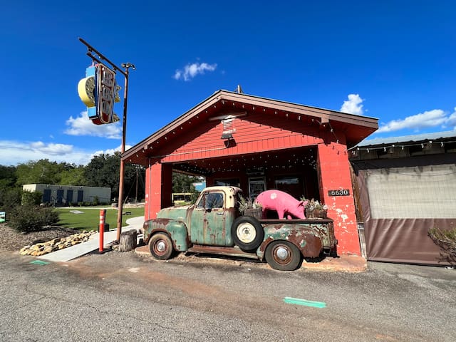
The Smokin' Pig
6630 Clemson BlvdThe Smokin' Pig on Clemson Boulevard in Pendleton is a great option for delicious BBQ and sides. Everything here is very well prepared and flavorful.
Fiestas Mexican Restaurant
712 West Main Street10 Minutes in downtown Pickens
Domino's Pizza
102 East Main Street10 minutes in downtown Pickens
Education
Clemson Üniversitesi
105 Sikes Hall35 Minutes
City/town information
Greenville is a city in South Carolina. It’s home to the Greenville County Museum of Art, with works by Southern artists spanning several centuries. Exhibits at the Upcountry History Museum tell the story of upstate South Carolina. Falls Park on the Reedy has riverside gardens, a suspension bridge and waterfall views. Multi-use trails wind around lakes and hills in Paris Mountain State Park, north of the city
210 yerel halk öneriyor
Greenville
Greenville is a city in South Carolina. It’s home to the Greenville County Museum of Art, with works by Southern artists spanning several centuries. Exhibits at the Upcountry History Museum tell the story of upstate South Carolina. Falls Park on the Reedy has riverside gardens, a suspension bridge and waterfall views. Multi-use trails wind around lakes and hills in Paris Mountain State Park, north of the city
Clemson is a city in Pickens and Anderson counties in the U.S. state of South Carolina. Clemson is home to Clemson University; in 2015, the Princeton Review cited the town of Clemson as ranking #1 in the United States for "town-and-gown" relations with its resident university
77 yerel halk öneriyor
Clemson
Clemson is a city in Pickens and Anderson counties in the U.S. state of South Carolina. Clemson is home to Clemson University; in 2015, the Princeton Review cited the town of Clemson as ranking #1 in the United States for "town-and-gown" relations with its resident university