
Nearby Parks
Sightseeing
12 min (11.9 km) via Trans-Canada Hwy/BC-1 S
Goldstream Provincial Park is a provincial park in British Columbia, Canada. It is known for the annual fall salmon runs in the Goldstream River, and the large numbers of bald eagles that congregate to feed at that time. The total size of the park is 3.79 km².
242 yerel halk öneriyor
Goldstream Eyalet Parkı
12 min (11.9 km) via Trans-Canada Hwy/BC-1 S
Goldstream Provincial Park is a provincial park in British Columbia, Canada. It is known for the annual fall salmon runs in the Goldstream River, and the large numbers of bald eagles that congregate to feed at that time. The total size of the park is 3.79 km².
25 min (26.9 km) via Trans-Canada Hwy/BC-1 S
This park is an ideal place for visitors of all abilities to explore nature. This 107 hectare Regional Conservation Area is steeped in cultural history and is ideal for exploring nature. Enjoy a stroll along the universally accessible Elsie King Trail, marvel at the heritage grove of ancient Douglas-fir trees, hike connecting trails to Thetis Lake Regional Park or visit the nature centre to discover more of the park’s natural and cultural history.
13 yerel halk öneriyor
Francis King Regional Park
Munn Road25 min (26.9 km) via Trans-Canada Hwy/BC-1 S
This park is an ideal place for visitors of all abilities to explore nature. This 107 hectare Regional Conservation Area is steeped in cultural history and is ideal for exploring nature. Enjoy a stroll along the universally accessible Elsie King Trail, marvel at the heritage grove of ancient Douglas-fir trees, hike connecting trails to Thetis Lake Regional Park or visit the nature centre to discover more of the park’s natural and cultural history.
27 min (25.8 km) via Shawnigan Lake Rd
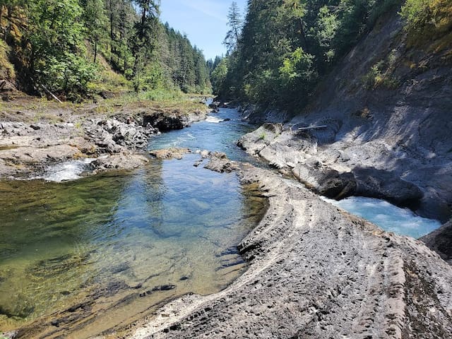
Adjacent to the Koksilah River, this undeveloped park in the Vancouver Island Forest Reserve offers good hiking, fishing and swimming opportunities. Spend an afternoon picnicking near the scenic surroundings of the Koksilah River and Canyon. This park is used mainly on weekends by residents of southern Vancouver Island, who come to the park to hike on the rustic trails and enjoy the river viewscape.
15 yerel halk öneriyor
Koksilah River Provincial Park
27 min (25.8 km) via Shawnigan Lake Rd
Adjacent to the Koksilah River, this undeveloped park in the Vancouver Island Forest Reserve offers good hiking, fishing and swimming opportunities. Spend an afternoon picnicking near the scenic surroundings of the Koksilah River and Canyon. This park is used mainly on weekends by residents of southern Vancouver Island, who come to the park to hike on the rustic trails and enjoy the river viewscape.
34 min (24.3 km) via Trans-Canada Hwy/BC-1 S
Gowlland Tod Provincial Park provides excellent day-use recreation opportunities for hiking, nature appreciation and picnicking. More than 25 kilometres of trails, varying in degree of difficulty, offer spectacular views, as well as the chance to view animals in their natural environment. In spring and early summer, the moss-covered rocky knolls come alive with a carpet of colourful, vibrant wildflowers.
33 yerel halk öneriyor
Gowlland Tod Provincial Park
Ross Durrance Road34 min (24.3 km) via Trans-Canada Hwy/BC-1 S
Gowlland Tod Provincial Park provides excellent day-use recreation opportunities for hiking, nature appreciation and picnicking. More than 25 kilometres of trails, varying in degree of difficulty, offer spectacular views, as well as the chance to view animals in their natural environment. In spring and early summer, the moss-covered rocky knolls come alive with a carpet of colourful, vibrant wildflowers.
36 min (35.6 km) via Trans-Canada Hwy/BC-1 S and Juan De Fuca Hwy/Sooke Rd/BC-14 W
West Coast wilderness awaits you at East Sooke Regional Park. Experience it as you hike along the windswept rocky coast, over dry hilltops, through dark rain forest to sheltered coves. This park
features: 50 kilometres of trails through forest, marsh and field; Challenging 10 kilometre Coast Trail; Pocket beaches, rocky bays and tide pools for exploring and scuba diving; and Spectacular views of the Strait of Juan de Fuca and Olympic Mountains.
95 yerel halk öneriyor
East Sooke Bölgesel Parkı
6807 East Sooke Road36 min (35.6 km) via Trans-Canada Hwy/BC-1 S and Juan De Fuca Hwy/Sooke Rd/BC-14 W
West Coast wilderness awaits you at East Sooke Regional Park. Experience it as you hike along the windswept rocky coast, over dry hilltops, through dark rain forest to sheltered coves. This park
features: 50 kilometres of trails through forest, marsh and field; Challenging 10 kilometre Coast Trail; Pocket beaches, rocky bays and tide pools for exploring and scuba diving; and Spectacular views of the Strait of Juan de Fuca and Olympic Mountains.
40 min (39.8 km) via Trans-Canada Hwy/BC-1 S and Juan De Fuca Hwy/Sooke Rd/BC-14 W
Adjacent to the park is the Sooke River, where there exists a series of deep, naturally carved and polished rock pools and a small parking area with facilities that is managed by the District of Sooke. This area is a favourite day-use destination for many local and regional residents.
Glacial action during the last ice age 15,000 years ago is responsible for the formations, as the moving, melting ice packs stripped the surface area and carved a path deep into the natural bedrock. Huge boulders carried along by the rushing river became lodged, were swirled against the canyon walls and consequently carved out the potholes that can be seen today.
222 yerel halk öneriyor
Sooke Potholes Provincial Park
Sooke River Road40 min (39.8 km) via Trans-Canada Hwy/BC-1 S and Juan De Fuca Hwy/Sooke Rd/BC-14 W
Adjacent to the park is the Sooke River, where there exists a series of deep, naturally carved and polished rock pools and a small parking area with facilities that is managed by the District of Sooke. This area is a favourite day-use destination for many local and regional residents.
Glacial action during the last ice age 15,000 years ago is responsible for the formations, as the moving, melting ice packs stripped the surface area and carved a path deep into the natural bedrock. Huge boulders carried along by the rushing river became lodged, were swirled against the canyon walls and consequently carved out the potholes that can be seen today.
46 min (48.7 km) via Trans-Canada Hwy/BC-1 S
Sooke Potholes Provincial Park is a 7.28 hectare provincial park in British Columbia, Canada. It is adjacent to the Sooke River and Sooke Potholes Regional Park, near Victoria, B.C. Intended primarily to provide access to the Sooke River and the associated potholes, it also offers wildlife viewing and other day-use activities.
29 yerel halk öneriyor
John Dean Provincial Park
46 min (48.7 km) via Trans-Canada Hwy/BC-1 S
Sooke Potholes Provincial Park is a 7.28 hectare provincial park in British Columbia, Canada. It is adjacent to the Sooke River and Sooke Potholes Regional Park, near Victoria, B.C. Intended primarily to provide access to the Sooke River and the associated potholes, it also offers wildlife viewing and other day-use activities.
49 min (62.0 km) via Trans-Canada Hwy/BC-1 N
Beautiful trails and a picnic area make Stocking Creek Park the perfect place for a nature walk. There are many trails meandering through the rainforest that lead to the creek and to the falls. The Cowichan Valley Trail also runs through the park offering a connection south to Chemainus and north to the Town of Ladysmith. Finch Place offers access to the Cowichan Valley Trail.
16 yerel halk öneriyor
Stocking Creek Waterfall
Stocking Creek Trail49 min (62.0 km) via Trans-Canada Hwy/BC-1 N
Beautiful trails and a picnic area make Stocking Creek Park the perfect place for a nature walk. There are many trails meandering through the rainforest that lead to the creek and to the falls. The Cowichan Valley Trail also runs through the park offering a connection south to Chemainus and north to the Town of Ladysmith. Finch Place offers access to the Cowichan Valley Trail.
49 min (56.2 km) via Trans-Canada Hwy/BC-1 N
If it’s outdoor recreation you’re after, Cowichan River Provincial Park on southern Vancouver Island is the place to go. Whether you want to go swimming, canoeing, white-water kayaking, tubing, camping, fishing or hiking, or just want to take it easy in the sun, you’re bound to find something to do in this “recreation corridor” south of Duncan.
https://www.airbnb.ca/things-to-do/places/596551
16 yerel halk öneriyor
Cowichan River Provincial Park
49 min (56.2 km) via Trans-Canada Hwy/BC-1 N
If it’s outdoor recreation you’re after, Cowichan River Provincial Park on southern Vancouver Island is the place to go. Whether you want to go swimming, canoeing, white-water kayaking, tubing, camping, fishing or hiking, or just want to take it easy in the sun, you’re bound to find something to do in this “recreation corridor” south of Duncan.
https://www.airbnb.ca/things-to-do/places/596551
1 hr 58 min (112.9 km) via Juan De Fuca Hwy/BC-14 W
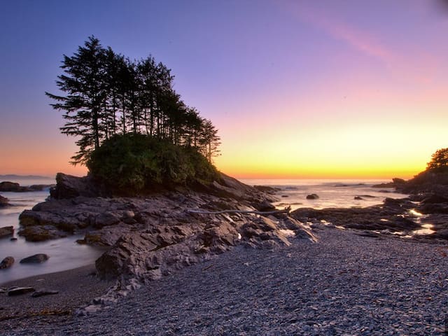
Botanical Beach is part of the Juan de Fuca Marine Trail and the corresponding Juan de Fuca Provincial Park. Best known for the abundance of life that lives within its sandstone tide pools and rock formations, Botanical Beach provides a habitat for hundreds of species of plants and animals.
25 yerel halk öneriyor
Botanical Beach Provincial Park
1 hr 58 min (112.9 km) via Juan De Fuca Hwy/BC-14 W
Botanical Beach is part of the Juan de Fuca Marine Trail and the corresponding Juan de Fuca Provincial Park. Best known for the abundance of life that lives within its sandstone tide pools and rock formations, Botanical Beach provides a habitat for hundreds of species of plants and animals.
1 hr 58 min (112.9 km) via Juan De Fuca Hwy/BC-14 W
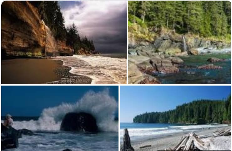
Juan de Fuca Provincial Park on the west coast of southern Vancouver Island offers scenic beauty, spectacular hiking, marine and wildlife viewing and roaring surf in its course along the Pacific coastline of the Strait of Juan de Fuca. There are four main areas to the park: the China Beach Campground, the Juan de Fuca Marine Trail, the China Beach day-use area and Botanical Beach.
12 yerel halk öneriyor
Juan de Fuca Provincial Park
1 hr 58 min (112.9 km) via Juan De Fuca Hwy/BC-14 W
Juan de Fuca Provincial Park on the west coast of southern Vancouver Island offers scenic beauty, spectacular hiking, marine and wildlife viewing and roaring surf in its course along the Pacific coastline of the Strait of Juan de Fuca. There are four main areas to the park: the China Beach Campground, the Juan de Fuca Marine Trail, the China Beach day-use area and Botanical Beach.