
Jill’s guidebook
Sightseeing
We have watched with interest the transformation of the ruins of historic Lowther Castle since 2012, a project in constant motion. Lowther Castle has belonged to the Lowther family, formerly the Earls of Londsdale since the Middle Ages. The current castle building, dates to the early 19th Century and today is a managed ruin with gardens which have been developed working alongside the natural beauty of the landscape and also as a means of recreating Lowther's identity. There is an adventure playground for children and also cycle hire. There is space, beauty, fresh air, interesting gardens, a fascinating historical display and great food and drinks and a small shop selling gift items.
97 yerel halk öneriyor
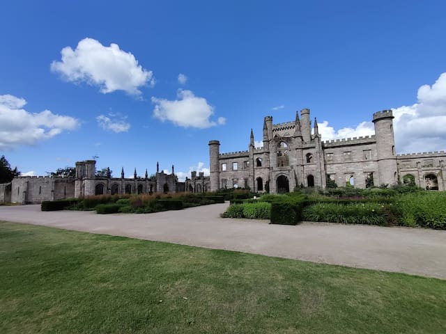
Lowther Castle & Gardens
We have watched with interest the transformation of the ruins of historic Lowther Castle since 2012, a project in constant motion. Lowther Castle has belonged to the Lowther family, formerly the Earls of Londsdale since the Middle Ages. The current castle building, dates to the early 19th Century and today is a managed ruin with gardens which have been developed working alongside the natural beauty of the landscape and also as a means of recreating Lowther's identity. There is an adventure playground for children and also cycle hire. There is space, beauty, fresh air, interesting gardens, a fascinating historical display and great food and drinks and a small shop selling gift items.
Walks, boat hire, kayaking, orienteering, stand up paddle boarding, archery, fishing (with permit) and tea shop.
Talkin Tarn is a 65-acre glacial lake set in 120 acres of farmland and woodland about 9 miles East of Carlisle and a 14-minute drive, or 44-minute cycle from Croglin along the B6413.
The tarn is glacial in origin, being formed about 10000 years ago, and is fed by underground streams. Fishing is available at the Tarn during the fishing season. A permanent orienteering course is laid out around the park. The shop hires mountain bikes and there are suggested routes taking you through beautiful countryside. There is a 1.3 mile walk on a good - quality path round the tarn. There is a tea shop which serves light meals, snacks, drinks and ice creams. The shop also sells fishing permits
17 yerel halk öneriyor
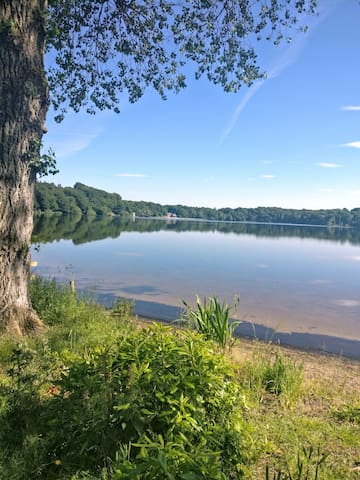
Talkin Tarn
Walks, boat hire, kayaking, orienteering, stand up paddle boarding, archery, fishing (with permit) and tea shop.
Talkin Tarn is a 65-acre glacial lake set in 120 acres of farmland and woodland about 9 miles East of Carlisle and a 14-minute drive, or 44-minute cycle from Croglin along the B6413.
The tarn is glacial in origin, being formed about 10000 years ago, and is fed by underground streams. Fishing is available at the Tarn during the fishing season. A permanent orienteering course is laid out around the park. The shop hires mountain bikes and there are suggested routes taking you through beautiful countryside. There is a 1.3 mile walk on a good - quality path round the tarn. There is a tea shop which serves light meals, snacks, drinks and ice creams. The shop also sells fishing permits
The National Trust's Acorn Bank, Cumbria, is set in a lovely, quiet location and is known for its large herb collection and traditional fruit orchard.
The gardens are well worth a visit as they have many medicinal and culinary herbs and then a walk through the grounds to the Watermill. There is also a pleasant cafe which serves drinks, light lunches, and refreshments.
14 yerel halk öneriyor
Acorn Bank Garden and Watermill
The National Trust's Acorn Bank, Cumbria, is set in a lovely, quiet location and is known for its large herb collection and traditional fruit orchard.
The gardens are well worth a visit as they have many medicinal and culinary herbs and then a walk through the grounds to the Watermill. There is also a pleasant cafe which serves drinks, light lunches, and refreshments.
Hutton in the Forest is a Grade I listed country house situated near the village of Skelton, at 13.2 miles (24 mins drive) from Croglin. It has belonged to the Fletcher-Vane family, latterly the Barons Inglewood, since 1605. Take a tour of the house through a succession of different historical periods and styles and then enjoy a gardens and woodland walk, followed by refreshment in the Cloister's tearoom.
13 yerel halk öneriyor
Hutton-in-the-Forest
Hutton in the Forest is a Grade I listed country house situated near the village of Skelton, at 13.2 miles (24 mins drive) from Croglin. It has belonged to the Fletcher-Vane family, latterly the Barons Inglewood, since 1605. Take a tour of the house through a succession of different historical periods and styles and then enjoy a gardens and woodland walk, followed by refreshment in the Cloister's tearoom.
Lovely, very well-maintained house and gardens with great cafe, the medieval tearoom. Run Historic Garden guided tours. Home of the World's Original Marmalade Awards.
23 yerel halk öneriyor
Dalemain Mansion & Historic Gardens
Lovely, very well-maintained house and gardens with great cafe, the medieval tearoom. Run Historic Garden guided tours. Home of the World's Original Marmalade Awards.
Walking
Circular 5 mile walk from Croglin via Newbiggin and back to Croglin. Total ascent 220m. OS Explorer OL5. Walk 23 'Walking in Cumbria's Eden Valley' Cicerone Guide by Vivienne Crow.
This walk is a frequent favourite of ours as it is accessible immediately from the front door of the house and is suitable for almost any time of year. Best of all though are the views along the way and the peace and quiet, so rarely achieved in modern day living.
Newbiggin
Circular 5 mile walk from Croglin via Newbiggin and back to Croglin. Total ascent 220m. OS Explorer OL5. Walk 23 'Walking in Cumbria's Eden Valley' Cicerone Guide by Vivienne Crow.
This walk is a frequent favourite of ours as it is accessible immediately from the front door of the house and is suitable for almost any time of year. Best of all though are the views along the way and the peace and quiet, so rarely achieved in modern day living.
Walk Armathwaite and Coombs Wood , either 3.5 miles (Walk 22 'Walking in Cumbria's Eden Valley' Cicerone Guide by Vivienne Crow) or 5 miles (Walking Country Eden Valley by Paul Hannon, Walk 1). OS Explorer OL5 - English Lakes North-East.
Another favourite walk which is suitable for most weathers. Armathwaite is an attractive village located on the River Eden 5.5 miles from Croglin (12 mins by car or 32 mins by bicycle) with two pubs, the Fox and Pheasant and the Duke's Head, both of which serve food.
An interesting point of note if ever you should happen to be in the area when there has been heavy flooding as was experienced in 2015 is that the bridge over the Eden at Armathwaite was one of the last bridges which remained open for access to the area.
Coombs Wood
Walk Armathwaite and Coombs Wood , either 3.5 miles (Walk 22 'Walking in Cumbria's Eden Valley' Cicerone Guide by Vivienne Crow) or 5 miles (Walking Country Eden Valley by Paul Hannon, Walk 1). OS Explorer OL5 - English Lakes North-East.
Another favourite walk which is suitable for most weathers. Armathwaite is an attractive village located on the River Eden 5.5 miles from Croglin (12 mins by car or 32 mins by bicycle) with two pubs, the Fox and Pheasant and the Duke's Head, both of which serve food.
An interesting point of note if ever you should happen to be in the area when there has been heavy flooding as was experienced in 2015 is that the bridge over the Eden at Armathwaite was one of the last bridges which remained open for access to the area.
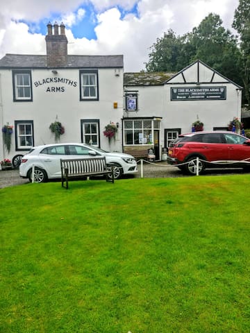
Talkin Tarn and the Gelt Walk (Walk 26 'Walking in Cumbria's Eden Valley' Cicerone Guide by Vivienne Crow), OS Explorer map 315, is a 7 3/4 mile walk and a total ascent 1,142 feet. It commences at Talkin Tarn and takes a very pretty route through Gelt Woods to the hamlet of Greenwell before returning to Talkin Tarn. It can be shortened at several points as desired and according to the weather. The Blacksmith's Arms at Talkin Village serves food and drinks.
9 yerel halk öneriyor
Gelt Woods
Talkin Tarn and the Gelt Walk (Walk 26 'Walking in Cumbria's Eden Valley' Cicerone Guide by Vivienne Crow), OS Explorer map 315, is a 7 3/4 mile walk and a total ascent 1,142 feet. It commences at Talkin Tarn and takes a very pretty route through Gelt Woods to the hamlet of Greenwell before returning to Talkin Tarn. It can be shortened at several points as desired and according to the weather. The Blacksmith's Arms at Talkin Village serves food and drinks.
A 4 mile return walk from the edge of Brampton (Walk 27 'Walking in Cumbria's Eden Valley' Cicerone Guide by Vivienne Crow, OS Explorer 315) town along the Ridgewood (a ridge of land with lovely views left by a huge glacier as it melted) and through Quarrybeck Wood down to Lanercost tea rooms and Priory, which is a good stop for lunch or drinks and refreshments. Quarrybeck Wood is especially pretty in May when all the bluebells are out.
Quarrybeck Wood
A 4 mile return walk from the edge of Brampton (Walk 27 'Walking in Cumbria's Eden Valley' Cicerone Guide by Vivienne Crow, OS Explorer 315) town along the Ridgewood (a ridge of land with lovely views left by a huge glacier as it melted) and through Quarrybeck Wood down to Lanercost tea rooms and Priory, which is a good stop for lunch or drinks and refreshments. Quarrybeck Wood is especially pretty in May when all the bluebells are out.
Talkin Fell (and Simmerson Hill) Walk (Walk 25 'Walking in Cumbria's Eden Valley' Cicerone Guide by Vivienne Crow, OS Explorer 315, Ascent 1280 ft). A 6 1/4 mile walk from Talkin Village, with a good pub, the Blacksmith's Arms serving food and drink, up to the summit of Talkin fell with its stone cairns which has one of the best viewpoints in this part of Cumbria and then , if you wish, up to the summit of Simmerson Hill. If not, then just descend back from Talkin Fell back down to Talkin village, picking up the same route as the descent from Simmerson Hill only a little lower down.
Talkin
Talkin Fell (and Simmerson Hill) Walk (Walk 25 'Walking in Cumbria's Eden Valley' Cicerone Guide by Vivienne Crow, OS Explorer 315, Ascent 1280 ft). A 6 1/4 mile walk from Talkin Village, with a good pub, the Blacksmith's Arms serving food and drink, up to the summit of Talkin fell with its stone cairns which has one of the best viewpoints in this part of Cumbria and then , if you wish, up to the summit of Simmerson Hill. If not, then just descend back from Talkin Fell back down to Talkin village, picking up the same route as the descent from Simmerson Hill only a little lower down.
Culgaith and Acorn Bank Walk (Walk 17 'Walking in Cumbria's Eden Valley' Cicerone Guide by Vivienne Crow), a 6 3/4 mile walk which takes in two attractive Cumbrian villages Culgaith and Temple Sowerby, as well as National Trust's Acorn Bank. National Trust's Acorn Bank is also worth a separate visit purely to visit the house and gardens alone.
Refreshments are available at the Black Swan Inn in Culgaith and at the National Trust Acorn Bank's tea room.
Culgaith
Culgaith and Acorn Bank Walk (Walk 17 'Walking in Cumbria's Eden Valley' Cicerone Guide by Vivienne Crow), a 6 3/4 mile walk which takes in two attractive Cumbrian villages Culgaith and Temple Sowerby, as well as National Trust's Acorn Bank. National Trust's Acorn Bank is also worth a separate visit purely to visit the house and gardens alone.
Refreshments are available at the Black Swan Inn in Culgaith and at the National Trust Acorn Bank's tea room.
Carrock Fell and High Pike ( 21.6 mile, 42 minute drive from Croglin). This walk starts from Caldbeck Common, North of Mosedale and is detailed in the Pathfinder Guide Lake District North and West Lakeland, Walk 19, 6 1/4 miles in length and 1,755 feet in ascent. Some great views from the tops and does not suffer from the overcrowding which can be problematic in more popular parts and summits of the Lake District National Park.
Carrock Fell
Carrock Fell and High Pike ( 21.6 mile, 42 minute drive from Croglin). This walk starts from Caldbeck Common, North of Mosedale and is detailed in the Pathfinder Guide Lake District North and West Lakeland, Walk 19, 6 1/4 miles in length and 1,755 feet in ascent. Some great views from the tops and does not suffer from the overcrowding which can be problematic in more popular parts and summits of the Lake District National Park.
Melmerby Fell walk, 8 3/4 miles (Walk 20 'Walking in Cumbria's Eden Valley' Cicerone Guide by Vivienne Crow). A more challenging walk which starts from the pretty village of Melmerby with its old tea rooms which is well worth a visit. There is open pathless moorland on the summit which can be wet.
Melmerby
Melmerby Fell walk, 8 3/4 miles (Walk 20 'Walking in Cumbria's Eden Valley' Cicerone Guide by Vivienne Crow). A more challenging walk which starts from the pretty village of Melmerby with its old tea rooms which is well worth a visit. There is open pathless moorland on the summit which can be wet.
Cross Fell, at 2930 feet, is the highest point on the Pennines whose summit is visible for miles around and from which can be seen the Vale of Eden to the Cumbrian mountains in the West, those of Scotland to the North, and the moorlands of Northumbria to the East. Our favourite route to the summit is via the old corpse road from Kirkland. It should be noted however, that this walk should not be underestimated as it is a challenging and long walk and should not be attempted in poor weather. It is very boggy in parts, particularly in the area around the summit. However, with the correct gear, persistence, and fine weather it is a spectacular walk which is not easily forgotten.
8 yerel halk öneriyor
Cross Fell
Cross Fell, at 2930 feet, is the highest point on the Pennines whose summit is visible for miles around and from which can be seen the Vale of Eden to the Cumbrian mountains in the West, those of Scotland to the North, and the moorlands of Northumbria to the East. Our favourite route to the summit is via the old corpse road from Kirkland. It should be noted however, that this walk should not be underestimated as it is a challenging and long walk and should not be attempted in poor weather. It is very boggy in parts, particularly in the area around the summit. However, with the correct gear, persistence, and fine weather it is a spectacular walk which is not easily forgotten.
City/town information
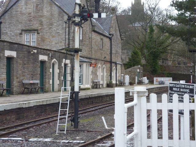
Alston shares the title of the 'highest market town in England', as it sits at about 1,000 feet above sea level, with Buxton, Derbyshire. It has a steep cobbled main street with a distinctive market cross. Many of its stone buildings date back to the 17th Century. It is the starting point for the South Tynedale Railway, England’s highest narrow-gauge railway.
There is a good 6 1/4 mile walk from Alston railway station (where there is also parking) along the South Tyne valley to the
Roman Fort of Whitley Castle and from there on to Kirkhaugh. This is followed by a return along by the track of the South Tynedale Railway and back to Alston station.
21 yerel halk öneriyor
Alston
Alston shares the title of the 'highest market town in England', as it sits at about 1,000 feet above sea level, with Buxton, Derbyshire. It has a steep cobbled main street with a distinctive market cross. Many of its stone buildings date back to the 17th Century. It is the starting point for the South Tynedale Railway, England’s highest narrow-gauge railway.
There is a good 6 1/4 mile walk from Alston railway station (where there is also parking) along the South Tyne valley to the
Roman Fort of Whitley Castle and from there on to Kirkhaugh. This is followed by a return along by the track of the South Tynedale Railway and back to Alston station.
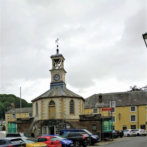
Penrith is the nearest market town to Croglin. It is historically interesting due to the ruins of its 14th Century Castle built by Sir Ralph Neville, who played an important role in the defence of the Scottish Border.
There is the Penrith and Eden Museum which is worth a visit as it houses displays of the archaeology, art, social, cultural and natural history of Penrith and the surrounding area.
76 yerel halk öneriyor
Penrith
Penrith is the nearest market town to Croglin. It is historically interesting due to the ruins of its 14th Century Castle built by Sir Ralph Neville, who played an important role in the defence of the Scottish Border.
There is the Penrith and Eden Museum which is worth a visit as it houses displays of the archaeology, art, social, cultural and natural history of Penrith and the surrounding area.
Hexham is well worth a visit (50-minute drive) as it is an interesting Northumberland market town with its historic Abbey which originated as a monastery founded by Wilfred in 674, the crypt of which has survived and has many Roman stones taken from local ruins, including Hadrian's Wall, although the current Abbey dates mainly from the 11th Century. Other interesting historic buildings include the Moot Hall and the Old Gaol and the covered market.
The town has also some good restaurants and places to eat, including 'Le Bouchon' French Bistrot, a winner of Gordon Ramsay's The F Word, 'Best local French Restaurant'.
A day out to Hexham can, if desired, be combined with a visit to Allen Banks and Staward Gorge, a National Trust area of woodland which is one of the largest areas of ancient woodland in Northumberland, for a walk , or just to admire the scenery.
For stocking up on shopping in Hexham, there are a wide range of stores including a Tesco's, Aldi, Waitrose and Marks and Spencer's stores as well as independent retailers.
84 yerel halk öneriyor
Hexham
Hexham is well worth a visit (50-minute drive) as it is an interesting Northumberland market town with its historic Abbey which originated as a monastery founded by Wilfred in 674, the crypt of which has survived and has many Roman stones taken from local ruins, including Hadrian's Wall, although the current Abbey dates mainly from the 11th Century. Other interesting historic buildings include the Moot Hall and the Old Gaol and the covered market.
The town has also some good restaurants and places to eat, including 'Le Bouchon' French Bistrot, a winner of Gordon Ramsay's The F Word, 'Best local French Restaurant'.
A day out to Hexham can, if desired, be combined with a visit to Allen Banks and Staward Gorge, a National Trust area of woodland which is one of the largest areas of ancient woodland in Northumberland, for a walk , or just to admire the scenery.
For stocking up on shopping in Hexham, there are a wide range of stores including a Tesco's, Aldi, Waitrose and Marks and Spencer's stores as well as independent retailers.
Keswick, in the Lake District National Park, is 32.6 miles (a 50 min drive by car) from Croglin. It is a busy market-town with a good selection of independent shops and places to eat. It is in a very picturesque setting as the huge mass of Skidday sits behind it and Derwentwater Lake sits in front. It has a theatre, 'Theatre by the Lake', and a good mini-golf course. It is however a popular place for visitors to the Northern Lake District National Park to visit and stay so it can get very congested at peak times.
Probably better avoided in peak periods unless you are a first time visitor when it is certainly worth a trip, taking in if you wish
a climb up one of the nearby fells such as Skiddaw or Cat Bells (+/- Maiden Moor and High Spy), alternatively a lower level walk around Derwentwater 9-10 miles or the walk up to Castlerigg Stone Circle.
205 yerel halk öneriyor
Keswick
Keswick, in the Lake District National Park, is 32.6 miles (a 50 min drive by car) from Croglin. It is a busy market-town with a good selection of independent shops and places to eat. It is in a very picturesque setting as the huge mass of Skidday sits behind it and Derwentwater Lake sits in front. It has a theatre, 'Theatre by the Lake', and a good mini-golf course. It is however a popular place for visitors to the Northern Lake District National Park to visit and stay so it can get very congested at peak times.
Probably better avoided in peak periods unless you are a first time visitor when it is certainly worth a trip, taking in if you wish
a climb up one of the nearby fells such as Skiddaw or Cat Bells (+/- Maiden Moor and High Spy), alternatively a lower level walk around Derwentwater 9-10 miles or the walk up to Castlerigg Stone Circle.
Historic, sight seeing, shopping
Carlisle Castle is situated at a 15.8 miles (34 minutes drive) from Croglin and can be combined with a visit to the Tullie Museum and a visit to Carlisle city with its shops and restaurants.
Today Carlisle Castle is managed by English Heritage. The original, most-likely wooden castle dates to the 11th century. It was replaced by a stone building by King Henry I of England in the early 12th century. In the 16th century Queen Mary, queen of Scots was imprisoned at the castle and in 1745 it was besieged by the Jacobite Rebellion. The building is in good condition and represents nine centuries of military and royal history near the Anglo-Saxon border. It has functioned at various times as a fortress, residence, for military training and as a prison. It is situated across the road from the Tullie Museum and adjacent to the confluence of the rivers Caldew and Eden and a short walk to Rickerby Park. There is good (payable) parking just to one side of the castle.
71 yerel halk öneriyor
Carlisle Kalesi
Castle WayCarlisle Castle is situated at a 15.8 miles (34 minutes drive) from Croglin and can be combined with a visit to the Tullie Museum and a visit to Carlisle city with its shops and restaurants.
Today Carlisle Castle is managed by English Heritage. The original, most-likely wooden castle dates to the 11th century. It was replaced by a stone building by King Henry I of England in the early 12th century. In the 16th century Queen Mary, queen of Scots was imprisoned at the castle and in 1745 it was besieged by the Jacobite Rebellion. The building is in good condition and represents nine centuries of military and royal history near the Anglo-Saxon border. It has functioned at various times as a fortress, residence, for military training and as a prison. It is situated across the road from the Tullie Museum and adjacent to the confluence of the rivers Caldew and Eden and a short walk to Rickerby Park. There is good (payable) parking just to one side of the castle.
Penrith Castle (now in ruins) is today managed by English Heritage and entrance is free. Penrith Castle was begun at the end of the 14th century by Ralph Neville, who played a key role in defending this area against the Scots. It was later transformed into a luxurious residence by Richard, Duke of Gloucester, who became Richard III. It provides evidence of the raids of the Border Reivers , for which this area is famous and dated between the late 13th to early 17th centuries.
It can, if wished, be combined with a shopping trip to Penrith and a visit to the Penrith and Eden Museum.
16 yerel halk öneriyor
Penrith Castle
Ullswater RoadPenrith Castle (now in ruins) is today managed by English Heritage and entrance is free. Penrith Castle was begun at the end of the 14th century by Ralph Neville, who played a key role in defending this area against the Scots. It was later transformed into a luxurious residence by Richard, Duke of Gloucester, who became Richard III. It provides evidence of the raids of the Border Reivers , for which this area is famous and dated between the late 13th to early 17th centuries.
It can, if wished, be combined with a shopping trip to Penrith and a visit to the Penrith and Eden Museum.
Historic and sight seeing
Managed today by English Heritage, Birdoswald Roman Fort is one of 16 forts lying along Hadrian's Wall, today a Unesco World Heritage site, and lies only a short distance from Lanercost Priory, so the two attractions can , if desired, be combined into a day trip.
It was formerly known as 'Banna' (which means 'horn' in Celtic) and is unusal in that it was continued to be used after Romans abandoned the site. It possesses many inscribed stones, such as altars, tombstones, and building stones which were left behind by the Dacians. The last inscribed stone found at Birdoswald dates to the late 3rd century. It records the rebuilding of the commander's house.
29 yerel halk öneriyor
Birdoswald Roma Kalesi - Hadrian Duvarı
Managed today by English Heritage, Birdoswald Roman Fort is one of 16 forts lying along Hadrian's Wall, today a Unesco World Heritage site, and lies only a short distance from Lanercost Priory, so the two attractions can , if desired, be combined into a day trip.
It was formerly known as 'Banna' (which means 'horn' in Celtic) and is unusal in that it was continued to be used after Romans abandoned the site. It possesses many inscribed stones, such as altars, tombstones, and building stones which were left behind by the Dacians. The last inscribed stone found at Birdoswald dates to the late 3rd century. It records the rebuilding of the commander's house.
Vindolanda and the Roman Army Museum is situated at 1 25.5 mile distance from Croglin (41 minutes by car), near to Bardon Mill in Northumberland.
It is the home of Britain's 'Top Treasure' - the Vindolanda Writing Tablets (the oldest surviving handwritten documents in Britain) - and is one Europe's most important Roman archaeological sites, with live excavations taking place every year.
The Roman Army Museum allows the visitor to recreate for themselves the experince of life as a Roman soldier. The museum includes three galleries, 3D film and holographic classroom. Based at the site of Magna Roman Fort the museum is situated next to one of the most complete sections of Hadrian’s Wall.
48 yerel halk öneriyor
Vindolanda
Vindolanda and the Roman Army Museum is situated at 1 25.5 mile distance from Croglin (41 minutes by car), near to Bardon Mill in Northumberland.
It is the home of Britain's 'Top Treasure' - the Vindolanda Writing Tablets (the oldest surviving handwritten documents in Britain) - and is one Europe's most important Roman archaeological sites, with live excavations taking place every year.
The Roman Army Museum allows the visitor to recreate for themselves the experince of life as a Roman soldier. The museum includes three galleries, 3D film and holographic classroom. Based at the site of Magna Roman Fort the museum is situated next to one of the most complete sections of Hadrian’s Wall.
Managed by English Heritage, Lanercost Priory was founded by Robert de Vaux between 1165 and 1174, to house Augustinian canons. It lies close by to Naworth Castle, with which it had close connections.
At 12.2 miles distance (23 mins by car and 1hr by bicycle )from Croglin, it is in a beautiful and tranquil setting with a number of short to medium-length walks which can be undertaken from the Priory.
The location of Lanercost Priory, so close to the Scottish border, has resulted in it always being vulnerable to attack in the Anglo-Scottish wars of the 14th century and it has quite a turbulent history . In 1311 it was raided by Robert the Bruce. In 1306-7 King Edward the 1st stayed at Lanercost Priory on their way North. It was destroyed in 1538 by Henry VIII at the time of the dissolution of the monasteries and is now in ruins.
Today though, the ruins of Lanercost Priory make a beautiful and interesting half day outing. In addition, there is a very pleasant tea room, Lanercost tea rooms, just adjacent to the Priory which serves drinks, cakes and light lunches.
It is also quite close to Birdoswald Roman Fort, also managed by English Heritage.
36 yerel halk öneriyor
Lanercost Rahibe Evi
Managed by English Heritage, Lanercost Priory was founded by Robert de Vaux between 1165 and 1174, to house Augustinian canons. It lies close by to Naworth Castle, with which it had close connections.
At 12.2 miles distance (23 mins by car and 1hr by bicycle )from Croglin, it is in a beautiful and tranquil setting with a number of short to medium-length walks which can be undertaken from the Priory.
The location of Lanercost Priory, so close to the Scottish border, has resulted in it always being vulnerable to attack in the Anglo-Scottish wars of the 14th century and it has quite a turbulent history . In 1311 it was raided by Robert the Bruce. In 1306-7 King Edward the 1st stayed at Lanercost Priory on their way North. It was destroyed in 1538 by Henry VIII at the time of the dissolution of the monasteries and is now in ruins.
Today though, the ruins of Lanercost Priory make a beautiful and interesting half day outing. In addition, there is a very pleasant tea room, Lanercost tea rooms, just adjacent to the Priory which serves drinks, cakes and light lunches.
It is also quite close to Birdoswald Roman Fort, also managed by English Heritage.
Shopping-food
Great place for shopping for local produce. It is the largest of the Cranston food halls and is home to the Cranston's butchery centre and kitchens. It contains a very large range of butchery and deli goods alongside quality produce from over 50 Cumbrian producers. There is also parking on site and a good cafe upstairs.
Cranstons Cumbrian Foodhall & Cafe Oswald's
Ullswater RoadGreat place for shopping for local produce. It is the largest of the Cranston food halls and is home to the Cranston's butchery centre and kitchens. It contains a very large range of butchery and deli goods alongside quality produce from over 50 Cumbrian producers. There is also parking on site and a good cafe upstairs.
James and John Graham's deli, artisan bakery and grocery store is situated on the main Market Square at Penrith and has been providing hampers, fine food & drink in Penrith, Cumbria since 1793 and on its current site since 1880. It has good customer service and a wide range of good-quality produce. We especially like their quiches, cooked meats, pasties, bread and scones.
7 yerel halk öneriyor
James & John Graham
6-7 Market SquareJames and John Graham's deli, artisan bakery and grocery store is situated on the main Market Square at Penrith and has been providing hampers, fine food & drink in Penrith, Cumbria since 1793 and on its current site since 1880. It has good customer service and a wide range of good-quality produce. We especially like their quiches, cooked meats, pasties, bread and scones.
Market Place, Brampton: Good weekly outdoor market each Wednesday, with stalls including, cakes, artisan bread, cheeses, fish and a local farmer's market once a month (usually last Saturday morning of the month).
Market Place
Market PlaceMarket Place, Brampton: Good weekly outdoor market each Wednesday, with stalls including, cakes, artisan bread, cheeses, fish and a local farmer's market once a month (usually last Saturday morning of the month).
Very well stocked and well - run local store. Nearest decent-sized food store to Croglin. Also has a post office.
Lazonby Co-Operative Foodstore & Post Office
B6413Very well stocked and well - run local store. Nearest decent-sized food store to Croglin. Also has a post office.
A little further afield ( 1 hour's drive or more) but still worth a visit if time
Park at Mardale Head and ascend over Rough Crag up to the summit of High Street ( 5 1/2 mile walk, 2,100 ft ascent. This ascent of High Street is detailed in the Pathfinder Guide series Lake District Eastern Lakeland, Walk 19. It is a great high-level walk. Alternatively, on High Street Summit, take the route over to the summit of Harter Fell and then drop down by Gatesgarth Beck back to Haweswater shore and the parking (7 miles).
21 yerel halk öneriyor
Haweswater Reservoir
Park at Mardale Head and ascend over Rough Crag up to the summit of High Street ( 5 1/2 mile walk, 2,100 ft ascent. This ascent of High Street is detailed in the Pathfinder Guide series Lake District Eastern Lakeland, Walk 19. It is a great high-level walk. Alternatively, on High Street Summit, take the route over to the summit of Harter Fell and then drop down by Gatesgarth Beck back to Haweswater shore and the parking (7 miles).
For those people who have never visited Newcastle upon Tyne and for those who have but would like a revisit, the University City on the Tyne and the major manufacturing hub in the Industrial Revolution is worth a visit. Our favourites are the Tyne Bridge, walking along the Millenium Bridge, the Quayside District, and the area around the Grey Monument. The Great North Museum is a must for anyone interested in history and for theatre lovers, the Theatre Royal. Add to this the shops and some good restaurants, whilst the drive is 58.3 miles (1hr 17 by car from Croglin) on a day when maybe the weather is not so good it makes a worthwhile visit. It is also possible to reduce the drive by catching the train at Brampton Station which travels right into the centre of Newcastle.
188 yerel halk öneriyor
Newcastle upon Tyne
For those people who have never visited Newcastle upon Tyne and for those who have but would like a revisit, the University City on the Tyne and the major manufacturing hub in the Industrial Revolution is worth a visit. Our favourites are the Tyne Bridge, walking along the Millenium Bridge, the Quayside District, and the area around the Grey Monument. The Great North Museum is a must for anyone interested in history and for theatre lovers, the Theatre Royal. Add to this the shops and some good restaurants, whilst the drive is 58.3 miles (1hr 17 by car from Croglin) on a day when maybe the weather is not so good it makes a worthwhile visit. It is also possible to reduce the drive by catching the train at Brampton Station which travels right into the centre of Newcastle.
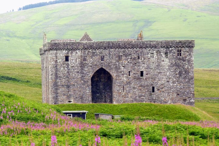
A longer drive (47.4 miles, 1hr 10 by car from Croglin) but given our fascination with Border history and the unique nature and location of this castle on the Scottish Borders, it has been added to our list of places well worth a visit, especially for anyone interested in Border Reiver history.
The castle is isolated, and the journey makes for an interesting day's drive but as a result has a formidable presence. It was targeted for 400 years for its role in controlling the Scottish Middle March and today has a reputation as one of the most sinister and atmospheric castles in Scotland. It is currently managed by Historic Scotland.
16 yerel halk öneriyor
Hermitage Castle
A longer drive (47.4 miles, 1hr 10 by car from Croglin) but given our fascination with Border history and the unique nature and location of this castle on the Scottish Borders, it has been added to our list of places well worth a visit, especially for anyone interested in Border Reiver history.
The castle is isolated, and the journey makes for an interesting day's drive but as a result has a formidable presence. It was targeted for 400 years for its role in controlling the Scottish Middle March and today has a reputation as one of the most sinister and atmospheric castles in Scotland. It is currently managed by Historic Scotland.
Bowness - on - Solway and Burgh by Sands. Bowness-on-Solway lies within the Solway Coast Area of Outstanding Natural Beauty and is a 29.2 mile (53 minute drive according to Google but in reality 1hr to 1hr 15) from Croglin. It is the starting point, or ending point, of Hadrian's wall.
A picturesque coastal village, popular with artists and bird lovers. There are viewpoints and lay-bys for spotting the waders: oystercatchers, curlew, golden and grey plover, lapwing, knot, dunlin, bar-tailed and black-tailed godwit, redshank, and turnstone. Many of the village houses, include stones taken from Hadrian’s wall.
A short walk takes you to Campfield Marsh RSPB Nature Reserve which is a mix of saltmarsh, peatbogs, farmland and wet grassland and provides homes for a variety of native wildlife, including ducks and geese in the winter and breeding waders, dragonflies and peat bog plants in spring and summer.
Burgh by sands is a pretty village situated on the route to Bowness on Solway and is the site of Burgh Marsh where King Edward I of England died as he planned another battle against the Scots. He had camped on the marsh in a place where his army could cross to Scotland at low tide.
8 yerel halk öneriyor
Bowness-on-Solway
Bowness - on - Solway and Burgh by Sands. Bowness-on-Solway lies within the Solway Coast Area of Outstanding Natural Beauty and is a 29.2 mile (53 minute drive according to Google but in reality 1hr to 1hr 15) from Croglin. It is the starting point, or ending point, of Hadrian's wall.
A picturesque coastal village, popular with artists and bird lovers. There are viewpoints and lay-bys for spotting the waders: oystercatchers, curlew, golden and grey plover, lapwing, knot, dunlin, bar-tailed and black-tailed godwit, redshank, and turnstone. Many of the village houses, include stones taken from Hadrian’s wall.
A short walk takes you to Campfield Marsh RSPB Nature Reserve which is a mix of saltmarsh, peatbogs, farmland and wet grassland and provides homes for a variety of native wildlife, including ducks and geese in the winter and breeding waders, dragonflies and peat bog plants in spring and summer.
Burgh by sands is a pretty village situated on the route to Bowness on Solway and is the site of Burgh Marsh where King Edward I of England died as he planned another battle against the Scots. He had camped on the marsh in a place where his army could cross to Scotland at low tide.